Showing posts with label significant weather event. Show all posts

Saturday, March 15, 2025

Variable Wet Season Weather & A Surprise From Mother Nature ... My Dry Tropics Garden, Beginning of Autumn, Week 11, March 2025

Garden Journal Entry - Week 11

This week's weather:


Seasons:  early Autumn & Wet Season
Daytime Temps:  29°C - 34°C            
Night Time Temps: 23°C - 25°C
Humidity Levels: 70 to 90%     
Hours of daylight:  12 hours 15 mins
Rainfall:  76 mm  (3 inches) 


A February To March Update

After nearly a month's break from my online garden journal, it's time to catch up on what's been happening in my garden from mid-February to mid-March (end of Summer and start of Autumn).  These past few weeks have been a whirlwind of weather events, with a setback or two, and a visit from a beloved family member.  Amidst all of this, there has been some progress out in the garden, and a lesson or two learned. 


Battling Heat, Heavy Rain and Humidity  (the usual summertime conditions)


The biggest challenge this past month (& the previous two months) has been the wet season conditions.  There is never a 'typical' wet season, so every year it's like starting over anew, awaiting whatever Mother Nature has in store!  Just because the rain finally makes an appearance in the summertime, that doesn't mean pleasant weather has arrived and it's paradise outside.

February this year brought record-breaking heat.  The day after I published my last garden journal blog post, the daytime high soared to 37.7°C, which ended up being the hottest day in the month of February, about seven degrees above average  (highlighted in red print and red background in the table below).


Weather Information for the Last Two Weeks of February 2025

Following that excruciatingly hot day, the daytime temps. sat up around 32 / 33 °C for the remainder of February.  With the high daytime humidity levels usually sitting round 60 to 70% as well, it felt more like 37°C each and every day for the last two weeks of February.  Some called it a "heatwave", but locals just called it "summer"!   


The conditions made gardening nearly impossible, except for very, very brief early-morning and late-evening sessions.


The intense UV rays made it even trickier for me, as I manage skin cancer issues and need to be cautious with sun exposure.  


The UV Index sat at 'high' to 'very high' by 8.00 am every morning and then shot up to 'extreme' by 10.00 am.  At that rating level, most people need to apply sunscreen every 15 minutes to protect their skin from harmful UV radiation.  I need to retreat indoors!


After the record-breaking rain that fell in early February, rain continued to fall to the end of that month resulting in a total of nearly 1200 mm / 47 inches, making February 2025 the wettest ever on record in our region.


The start of March, and the start of our Autumn, saw a short break in the rainfall, but not the heat.  We have seen record daytime highs continuing, along with the oppressively high humidity levels.


Weather Information for the First Two Weeks of March


This past week has seen the return of rain, usually arriving in the afternoons after stifling, sweltering mornings.  These afternoon showers and the cool breezes that have followed bought about noticeable changes in temperatures at the end of the day.


While the rain over this last week has provided relief at times from the heat, the rain over this whole wet season has caused hurdles for the garden which need continued attention - waterlogging, nutrient leaching and soil compaction.


Visitor Stay


A delightful interruption came in the form of a visitor who ended up staying longer than expected.  His return home flight was cancelled a couple of times, because of an impending cyclone that was expected to cross the coast down south near our state's capital city, near his home.  Whilst that caused him some concern, we were glad his stay continued a little longer than planned.  Thankfully, Cyclone Alfred caused little trouble at his place!

While the visitor's stay paused my gardening activities, it offered a welcome break filled with leisurely breakfasts, local explorations, and insightful conversations.  It was wonderful taking the time to create new treasured memories.


Dealing With Injury


Just as I was getting back into the swing of things, I injured my knee, forcing another gardening hiatus.  Even simple tasks like weeding had to be put on hold.  It was a frustrating setback, but it reminded me that garden maintenance can become a little more difficult as one ages, requiring a deal of patience and forethought when it comes to the lifting and moving tasks that are often required.  


Garden Progress Amidst All Of This:


Pruning and Cleanup


The excessive rain encouraged rapid plant growth, resulting in some plants becoming leggy and weak.  Constant downpours also caused branches to snap or break off entirely.  Once the rain eased, the sudden full-sun exposure scorched leaves, adding to the damage.

To counteract this, I focused on pruning - removing damaged parts to promote healthier, stronger regrowth.  My other half and I tackled the fallen branches and green debris, overfilling a large trailer before taking it all to the local waste facility.


Another major task was clearing out overgrown ferns in one section of the shade house garden.


Thankfully, they were easy to pull out, though I still managed to fill five wheelbarrows with the debris so it became a bigger job than expected!


Once cleared, I added a fresh layer of mulch to help retain moisture for the coming dry season and suppress further overgrowth.


I also moved some of the potted plants around to give the spaces a bit of a re-vamp.


Driveway Garden Makeover


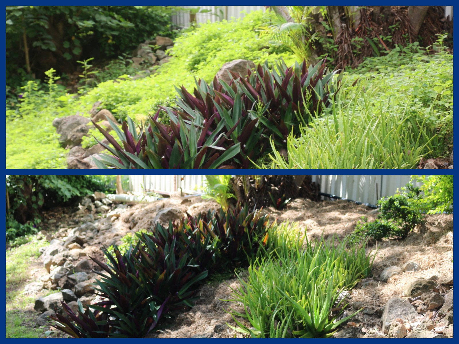
One of the most noticeable improvements was the completion of the weeding and mulching job on one section of the long driveway garden beds.  The difference is striking.  The photos above show just one end of this section.   You can see just how lush the weed growth was in the top photo and what the rocky garden bed looks like now it's cleared of all those noxious weeds.  


This end though remains a bit of a challenge - the rocky, exposed area has proven difficult for plant success.  I've tried hardy plants like Russelia, Crotons and others over the years, but nothing has thrived.  Leaving it bare isn't an option, so I'll need to do some thinking and planning.  I want something that will provide colour, will survive in full sun, will grow in poor soil and won't take over the space completely.


Soil Restoration and Nutrient Boosting 


The record rainfall received this wet season has taken a toll on soil quality, particularly in the courtyard garden beds, washing away essential nutrients.  To remedy this, I have applied a top dressing of general-purpose fertiliser with trace elements.


In areas where the rain had caused severe soil compaction, I have added nutrient-rich soil to restore balance.


Fascinating Plant Adaptations


One of the most intriguing observations from this wet season has been the response of certain plants - Acalyphas, Coleus and Begonia - to the prolonged moisture.  They began producing aerial roots, likely as an adaptation to oxygen-deficient conditions caused by waterlogging.  This natural survival mechanism helped them absorb additional oxygen and moisture, a fascinating reminder of how resilient plants can be.


Looking Ahead:  Next Steps In The Garden

As we move through March, my focus will be on:

Re-potting plants affected by the wet season
Continuing soil enrichment to restore lost nutrients
Further pruning and reshaping plants for healthier growth
Planning and experimenting with new plants in the problem areas


Despite the setbacks, every day in the garden is an opportunity to learn as a caretaker of this ever-evolving garden.  The changing seasons always bring new challenges, but they also bring renewal and fresh possibilities.  


A Surprise Event At The Start Of March


March 1st brought an unexpected shock - literally!  At 9.39 pm, our region experienced a 4.4 magnitude earthquake at a depth of 10 metres.  The epicentre was close to Townsville, and the tremors shook houses across our city. 

For those of us near the epicentre, the seismic waves arrived suddenly and in one intense burst, making for a frightening experience.  Those farther away felt a slower, rolling, rumbling motion.  Around 4,000 properties lost power, but thankfully there were no injuries or major damage reported.

After the record-breaking rainfall in February, an earthquake was the last thing any of us expected.  It was a stark reminder of how unpredictable Mother Nature can be.


This Week's Garden Highlights: What's Blooming?


Until next time,

🌸 Happy gardening from the northern dry tropics!


Saturday, February 8, 2025

The Arrival Of The Wet Season ... My Dry Tropics Garden Journal, Mid to Late Summer, Weeks 5 & 6, February 2025


For reasons that will become apparent with further reading, I'm posting one journal entry for the two weeks from Jan 26 to Feb 8.


Garden Journal Entry - Week 5 

This week's weather:

Seasons:  Mid-Summer & Wet Season
Daytime Temps:  26°C - 35°C              ("Quite a range!", you might say.  Yes, you are correct.  Read on.)
Night Time Temps: 23°C - 27°C
Humidity Levels: between 70% & 100%     
Hours of daylight:  13 hours
Rainfall:  123 mm (4 inches)  from 9.00 am Sunday to 9.00 am Friday (the last day of January), 
then .... 284 mm (11 inches) from 9.00 Friday to 9.00 Saturday 
and then .... another 260 mm (10 inches) from 9.00 Saturday to 9.00 am Sunday!!!!!!   


Wet season is always an interesting time for gardeners, but this year, after a rather benign start, it's suddenly become quite a challenging period for both plants and gardeners alike.  Let's see how things changed.

The Story of January 2025:  From Dry Heat To A Deluge

January 2025 was a month of extremes.  For most of the month, we experienced relentlessly hot, humid and dry conditions, with daytime highs running about 2°C above the long-term average.  While that may not seem like a significant increase, over a month-long period, it makes a noticeable difference, amplifying the stress on the garden and the discomfort of the gardener.  The high humidity made those temperatures feel closer to 40°C on some days, making even simple gardening tasks a challenge.


The total rainfall for January was a mere 148 mm - less than half the historical average recorded since 1941.  The primary reason?  The delayed arrival of the monsoon trough.


This image shows some of the global rainfall daily averages for the months of January and July.  The monsoon trough is usually positioned over northern Australia in the southern summer month of January (as shown of the left), and then moves northward to sit along the equator during our southern winter.
It is the monsoon trough that brings areas of low pressure and sustained heavy rainfall.  This happens during what we refer to as "the wet season".  The beginning of a wet season is variable, but it usually happens during January. 


When The Rains Came 

On the very last day of January, after weeks of oppressive heat and inadequate rainfall, Townsville and its surrounding areas were suddenly hit in the afternoon and evening with a staggering 280 to 300 mm of rain, and then the deluge continued the next day with another 260 to 280 mm (recorded at the Townsville airport in the city).  That's a lot of rain - 21 to 22 inches in 48 hours


An area of low pressure had converged over Townsville and its surrounds and remained there for the following week.   The downpours were relentless.  Here in my outlying rural suburb, we received almost 500 mm (almost 20 inches) in that same period.


A Year's Worth Of Rainfall In Just Five Weeks

To put things into perspective, Townsville's annual average rainfall is 1137 mm.  With 1139 mm recorded up to the end of Week 5, the city has already exceeded its yearly average just five weeks into the year.


This milestone comes after a record-breaking December 2024, when Townsville Airport (in the inner city) set a new rainfall record with 487 mm, bringing the three-month total to a staggering 1626 mm! 


In the days leading up to this torrential rain, at the start of Week 5, my garden was already enjoying a respite from the heat, with three days of light showers keeping the plants fresh.  Blooms were adorned with raindrops that lingered all day, creating a scene I hadn't witnessed in over a year.  A gentle stream trickled down our driveway, and the wallabies revelled in the new abundance of greenery.  


Despite the damp conditions, I was still able to get outside between showers to tackle the ever-persistent pests - tiny bright green grasshoppers and caterpillars that were feasting on many of the plants; and a stubborn infestation of mealybugs in the shade house and pergola gardens.

Another of my gardening tasks during this time was tending to the pergola garden space which had suffered while I was away just a fortnight before.  Between pest management and nurturing struggling plants, it was a busy period.  But once the deluge of rain arrived, all of these activities came to a screeching halt.


Garden Journal Entry - Week 6


Seasons:  Late-Summer & Wet Season
Daytime Temps:  25°C - 30°C            
Night Time Temps: 21°C - 24°C
Humidity Levels: between 90% & 100%     
Hours of daylight:  13 hours, but there was almost constant cloud cover from horizon to horizon
Rainfall:  482 mm  (18 inches)

The month of February began on the final day of Week 5, so Week 6 covers the first week of February.  Gardening chores were put on hold this past week, as it's been raining almost constantly, sometimes quite heavily.  Everything is sodden underfoot with some areas of the garden slightly under water and very slippery.  My Week 6 entry is therefore mostly about the weather event that has impacted the region of Northern Queensland where I live.


When A Common Weather System Turns Extreme

Northern Queensland, is no stranger to tropical weather, but this week has been nothing short of extraordinary.  While no destructive cyclone made landfall, a series of unfavourable conditions transformed a relatively common weather system in to a record-breaking weather event.  For some, it's been a catastrophic event, surpassing all expectations in terms of rainfall and impact.


A tropical low, which originally formed off the coast of Cairns (around 600 km to the north of my home city of Townsville) on January 28, has inundated the northern region with staggering amounts of rain.  Some areas recorded nearly two metres of rainfall in just a few days.  The event claimed two lives, with the potential for more rain in the forecast.


What Caused The Torrential Rain?

Tropical lows are a routine part of our northern Australian wet season, often seen as the early stages of cyclones before their winds reach destructive strength.  While lows form multiple times a year, most do not raise major concerns.  Typically, these systems bring moderate rain and are manageable withing the region's preparedness frameworks.


However, two critical factors intensified this particular system:

-  Slow movement of the low.  After forming, the tropical low drifted away from the coast for several days where it stalled, continuously drawing moisture from the warm ocean waters.  When it turned and headed back inland, this sustained moisture influx resulted in torrential downpours days on end, overwhelming local drainage systems and causing widespread flooding. 

-  Unusually warm Coral Sea.  The sea surface temperatures in the Coral Sea have been significantly warmer than usual.  Warmer waters lead to increased evaporation, which in turn fuels heavy cloud formation and intense rainfall.

Photos taken around Townsville


The Impact Of Record Rainfall

This past week has been one of the most challenging times for my city of Townsville and its surrounding communities, as relentless rainfall and severe flooding wreaked havoc across northern Queensland.  A 735 km stretch of coastline from Cairns to Mackay has been impacted, with Townsville, Ingham and Cardwell among the worst hit by flash floods and overflowing waters.


Both Ingham (270 km north of Townsville) and Cardwell (320 km north) were completely cut off, with highways closed due to floodwaters.  Residents faced power outages and a compromised water supply, forcing authorities to cut off access to drinking water.  With roads impassable, grocery supplies dwindled rapidly, leaving communities struggling to secure essentials.


Townsville - the largest city in northern Queensland - is a sprawling city covering an area of almost 3,750 square kms, and includes 98 suburbs.  Normally, rainfall is inconsistent across the city.  The inner city can be drenched while the outer suburbs remain dry.  During this weather event, all suburbs received rain, but as usual, it varied across the city. 


Many of the northwest suburbs recorded massive rainfall totals at the start of the week compared to the suburbs located on the outskirts to the south.  The suburb of Rollingstone, 60 km northwest of the Townsville city centre, recorded a whopping 702 mm over the 24 hours to 9.00 am on February 2nd, while the Townsville Airport (in the inner city where the weather station is located) recorded 545 mm, and my suburb received around 486 mm over that same period of time.


This graphic shows the difference in rainfall totals across the Townsville local council area from 9.00 am on the 2nd of February to 9.00 am on the 3rd.  The black box in the top left hand corner shows the 24 hour total for the northern suburb of Paluma, while the yellow box on the left shows the 24 hour total for my rural suburb on the southern outskirts.  All the red dots in the centre indicate the varied totals for the inner city suburbs.


By Sunday, February 3rd, low-lying inner city suburbs, such as Rosslea, Oonoonba, Railway Estate and Stuart, were declared "black zone" areas and residents were told to evacuate.  Police went door to door informing home owners that it was in their best interest to leave their home and go to the nearest emergency shelter.  Small armies of support workers were there to provide everything from bedding and towels to pet food and counselling.


Suburbs located along the Ross River were also included in the "black zone" area as the river's water level rose quickly.  Water levels in the city's Ross River Dam, which fed into Ross River, rose over the dam's 100% capacity and our local authority began releasing water through spillways to relieve pressure.  This of course added to the already increased volume in the Ross River.  Many residents in homes close to the swollen river began sandbagging their properties in an effort to keep out the rising water. 


Townsville's Ongoing Flood Risk:  Dam Levels, River Rises and More Rain To Come

A contributing factor in the city's flooding has been the Ross River Dam.

The following graphic shows the level of our dam over this past week:


The blue line indicates that the dam's capacity has been consistently above 100% (the straight black line) since the 1st of February.


This excess water has contributed to the rapid rise of the Ross River, which reached between moderate and major flood levels earlier this week. 


While river levels have begun to drop, the threat is far from over, as new tropical lows continue to form along the monsoon trough bringing the potential for further heavy rainfall in the coming days.

When the flooding peaked at the start of this week, Townsville came to a complete halt.  Roads across the city were closed due to the rising water, cutting off entire suburbs.  Shops shut their doors, unable to operate amid the chaos.  Schools were closed.  Bus services and the airport ceased operations.


By mid-week, the most intense rainfall had eased, allowing floodwaters to begin receding.  However, with new lows developing, authorities remain on high alert for another potential surge.  


With the wet season still ongoing, the big question remains - how much more rain will fall?  


The February rainfall record for Townsville has already been broken, and we're only eight days into the month!  2025 is  shaping up to be a year for the record books.


The latest radar and satellite imagery (8.45 pm on Saturday, February 8):


The monsoon trough still lies across Northern Queensland in an environment rich with tropical moisture, allowing the development of slow-moving heavy showers and severe thunderstorms.  Significant rainfall is predicted to continue into next week.


A Rural Perspective:  My Property's Experience

Living in a rural suburb on the southern outskirts of Townsville, my experience of the flood event has been somewhat different from those in the inner city and north-western suburbs.


Rainfall totals in my area have been slightly lower, meaning flooding has not been as severe.  

Photos from around my suburb at the start of the week


Roads providing access to our suburb from the highway were under water for a couple of days at the start of this week, but they cleared fairly quickly.  Properties were also flooded but very few homes were actually inundated with flood water.


My property sits in an elevated position, allowing excess water to drain away quickly.


While two flat areas have gone underwater - the shade house garden floor and the paved courtyard garden - the water only reached a few centimetres deep.


Though these minor floods have made some outdoor areas slippery and unsafe, my garden has benefited significantly from the extra rainfall.  Most plants are flourishing in this historic wet season. 


This Week's Garden Highlights:


Until next time,

🌸 Happy gardening from the northern dry tropics!